It is efficent when the land is flat, and some thought was put into the roads in some of these places, as the road were laid out after cars were invented. That is the number one reason for all the crooked roads in hilly regions, as horses couldn't haul carriages up and down big hills easily.
You are using an out of date browser. It may not display this or other websites correctly.
You should upgrade or use an alternative browser.
You should upgrade or use an alternative browser.
funny: Iowa counties
- Thread starter Jeslek
- Start date
LastLegionary said:There is a good reason why counties are so nice and squareish in North America and Canada.
eh?

 did we move and no-one told me?
 ris
New Member
not at all
how about a little bit of basic urban planning education?
it is because london evolved as a town adn then city, deleoping from rough tracks and trade routes that related to most navigable river routes and land-tracks.
also, the notion of a cartesian grid layout for cities only developed in much later, and once a city has a medieval plan it is very hard to fit a grid to it after, especially around monuments and major buildings.
hence why most european cities introduced grids after major disasters [earthquake and fire in lisbon's case, for example]. in paris, baron haussman was given carte blanche to work on the city and while he widened routes to major buildings he did not introduce a pure grid as it was too hard to fit to the existing structures.
new york, like the majority of us cities i believe, was a much later development and could use a pure grid system from the outset, allowing what was in reality an urban planning 'idea' that had only been tested in small 'experiments' [lisbon, barcelona etc] to be tried from the beginning.
london briefly toyed with a grid after the fire of 1667 but implemtation was slow and eventually a reduced version of the haussman ideas [widened boulevards and openend squares as seen in paris and rome].
if you want to be brutal it is because the european cities have a greater history. neither planning system is better than another, if the ancient city plans were unworkable then they would have been abandoned and grid layouts advanced earlier, especially during the renaissance when ideas of pure geometry and proportion were developed.
if you want to know more about the evolution of cities, layouts and urban planning then a good start are the spiro kostov books.
Stop Laughing
New Member
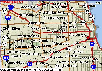
hehe, Chicago's basically a grid, too. Here's a map (you can see where Schiller Park is in relation to the rest of Chicago, and the gray blob in the middle of the words "Wood Dale" is O'Hare Airport) of the Chicago area:
Attachment(s):
chicago.jpg, 46.22kb

Attachment(s):
chicago.jpg, 46.22kb

Jeslek
Banned
Aye I know that. While I prefer the grid system, I can certainly appreciate London for its archaic layout (in a good sense). I love the small streets, twisting, circular, and so on. Reminds me a lot of medieval times, which I am really interested in. Walk in New York and it reminds you um, nothing... England and Europe has so much culture developed over thousands of years, which I can really appreciate. A chateaux in Connecticut just ain't the same as one in France or England 
Rome is different. Everything was built around the Vatican, and as a result major roads travel OUTWARDS from Vatican. That creates a kind of a weel pattern, making "blocks" become triangular. Weird as hell.
Rome is different. Everything was built around the Vatican, and as a result major roads travel OUTWARDS from Vatican. That creates a kind of a weel pattern, making "blocks" become triangular. Weird as hell.
Jeslek
Banned
Correction, one way streets are there to help ease with nongrid cities. Cities with grids may sometimes benefit from one ways, but nongrid cities gain by far the most in terms of easing traffic. We don't have one ways around here, but I know London has a lot, Cape Town has a lot (British design), and Kuala Lumpur has a lot (also British design). Johannesburg and Pretoria in South Africa are of grid design and has virtually no one ways.ris said:incidentally, the one-way systems are a product of modern automobile use, and grid cities use them too to ease traffic flow
Stop Laughing
New Member
There's several one way streets in Chicago, but the vast majority of them are residential streets, it deters the traffic from disrupting neighborhoods. BTW, just for your information, my house is on a one way street. 
ris
New Member
rome is a curious city, while the vatican is much of its focus it was not built that way but adapted to in the renaissance. the ideas begun there influenced many others [haussman include] and the core of them was the architectural promenade.
streets were widened to create vistas to major landmarks, important churches and temples [pantheon, for exampe] has squares and piazza's placed in front of them. most importantly ancient roman buildings were highlighted and reverred as lineage to modern rome [colloseum, hadrian's mausoleum etc].
the city was not built as a wheel but changed into one, with the focus of the architectural promenade as the vatican and st peter's basilica and piazza. most of the city is not affected by the spokes, they are ended by monuments and other buildings. in effect, ancient rome and renaissance rome are fused as an intellectual tourist trail for 'enlightened' people of the time.
incidentally, many european towns and cities have circular rings around them, either major roads or links of gardens [as in copenhagen]. these are usually the line of the old city walls, demolished and moved outward whenthe city became full. they are infrequently seen with spokes, although the ideas of the garden city and ebeneezer howard put the circular town as the model for modern urban life in the late 19th century.
ris
New Member
LastLegionary said:Correction, one way streets are there to help ease with nongrid cities. Cities with grids may sometimes benefit from one ways, but nongrid cities gain by far the most in terms of easing traffic. We don't have one ways around here, but I know London has a lot, Cape Town has a lot (British design), and Kuala Lumpur has a lot (also British design). Johannesburg and Pretoria in South Africa are of grid design and has virtually no one ways.ris said:incidentally, the one-way systems are a product of modern automobile use, and grid cities use them too to ease traffic flow
as already stated above and expanded on by yourself the one-way streets are an addition to the non-grid city as a consequence of the later development and congestion of automobiles.
i have visited several grid planned cities in europe and have seen one-ways there and i can only assume that they are for the same puropse.
hence no correction to make, my statement is still valid - one ways are used in grid cities, i made no reference to frequency, just their existence.
Stop Laughing
New Member
You can sort of put Lake Shore Drive (LSD 
 ) in the category of a city-border street, but putting a major street there was really a no-brainer, there's no way to drive east of it unless your car can imitate Moses.
Grid systems are so easy, especially when you have a good sense of direction like me, you'll never get lost.

Grid systems are so easy, especially when you have a good sense of direction like me, you'll never get lost.


 . Left-side driving doesn't make it easier either... But the city is nice, I wish I could go there more.
 : myself.
